Velu told me that he had seen people with different instruments probe the water to measure its levels of toxicity. “But they never enter the water. Why don’t they just ask us fishermen? After all, only by entering the water do we make an income.”
The industrialization of Velu’s landscape has heavily affected the river that supports his income. The presence of copper, zinc and mercury has been confirmed by different scientific tests that were designed to measure the levels of bioaccumulation that aquatic life in the river had endured. But Velu knows that the water is polluted. His body, he insisted, was enough to make sense of it.
In the image above, Velu and Surya are drawing the nets they had set up in the river, back onto the boat. Both the action of setting up the nets and the work needed to draw them back on the boat demands the body to be fully or partially immersed in the water. His feet traverse the riverbed, making calculations of its depth and consistency. His body measures the strength of the current as he sets up the nets to withstand its force. His hands work through the nets in the water, untangling any unnecessary accretion that might hamper the proper functioning of his nets. All routine calculations of their river and all measured by their body.
At first glance this image might just appear as two men in the process of fishing. But I wish to reorient our reading of the image. This image is also a representation of the body’s intimacy with toxicity. Not solely as victims of industrial pollution, but also as “embodied empiricists” in their own landscape. Knowing that the water is polluted changes our perspective of the two men. But it is in knowing that both Velu and Surya are well aware of the water’s pollution, through its influence on their body and in their place, can we visualize what we otherwise might believe only lies beneath the surface.
After drawing the nets on to the boat, Velu and Surya sort out their catch. Small prawns form one cluster, the few tiger prawns another, while the rest of the catch is released back in the water. The process of segregation is a long and tedious one. Once complete, Velu and Surya transfer each pile in to different baskets, storing them in an icebox at the very end. They both sigh in relief and rest their backs to the sides of the boat, finally looking out into the distance as opposed to the floor of their boat.
“It used to be scary before the companies came… forests all around… you could even hear jackals at night. I used to get really scared but now… you can see for yourself… this is what happens when the companies come”.
Velu tells me this with his eyes fixed on the power plant in the distance. We see the plant puff away flushes of steam from its stacks, illuminating a once “scary” place with its hyper visible presence. But can we envision its absence? It is precisely this, thinking of the same place without a power plant, without chimneys puffing steam, without incandescent lights setting dark skies on fire, without mercury in the water and in the fish, without the mechanized sounds of energy infrastructures mingling through the day and night, without the smells of an industrial intruder, without “toxicity”, that Velu remembers vividly. This sensorial transformation of place, from jackals to smoke stacks, is where toxicity becomes visible. While this experience is intimate and is a memory that is located in certain bodies, thinking through the absence of ‘toxicity’ in the image above, might help the viewer rethink what is actually there.
After the nets are drawn on to the boat, Velu and Surya keenly inspect them, ensuring that all of the catch falls to the floor, and that there isn't much damage to them. Most often there isn't anything beyond a few frayed ends that would easily be mended the next day. But the nets tell another story that remind the fishers of their toxic landscape. Caked in the residues of the coal-fired thermal power plants that surround them, the once blue nets have incresingly accomodated the greys and blacks of coal dust and slurry. "They look dull now" was Velu's way of telling me that there is something else, in the air, in the water, in his body and his nets, that could be measured by the senses. The material life of things that ineract with the lives of fishers, are equally places were toxicity becomes visible.
Towards the end, Velu and Surya pile the catch together and store it in an ice box. Depending on the size of their catch, fishers choose to sell the shrimp and prawns at the smaller local market or the central fish market that attracts consumers that buy in larger quantities. However, both Velu and Surya insisted that the size of their catch had significantly reduced since the construction of the power plants. This coupled with an increasingly silted river that suffered from numeorus infrastructures that impeded its tidal rhythym only aggrevated their concerns for their landscape. But when a study suggested that the industrial discharge that was let in to the river had accumulated in to the life of their catch, the headman of the fishing village insisted that the reports were false. "We eat what comes out of the river and nothing happens to us", he said proudly, and assured that the same would be true for me. While toxicity makes itself visible to the fishers in this landscape, it is selectively rendered invisible as well. The boundaries of visible and invisble toxicity, though porous, suggests a complex politics of measure that traverse the daily lives of human and non-human actors in a toxic place. I intend for this image to be read in that light. Can we look at it and ask ourselves where the entangled boundaries of toxicity end?
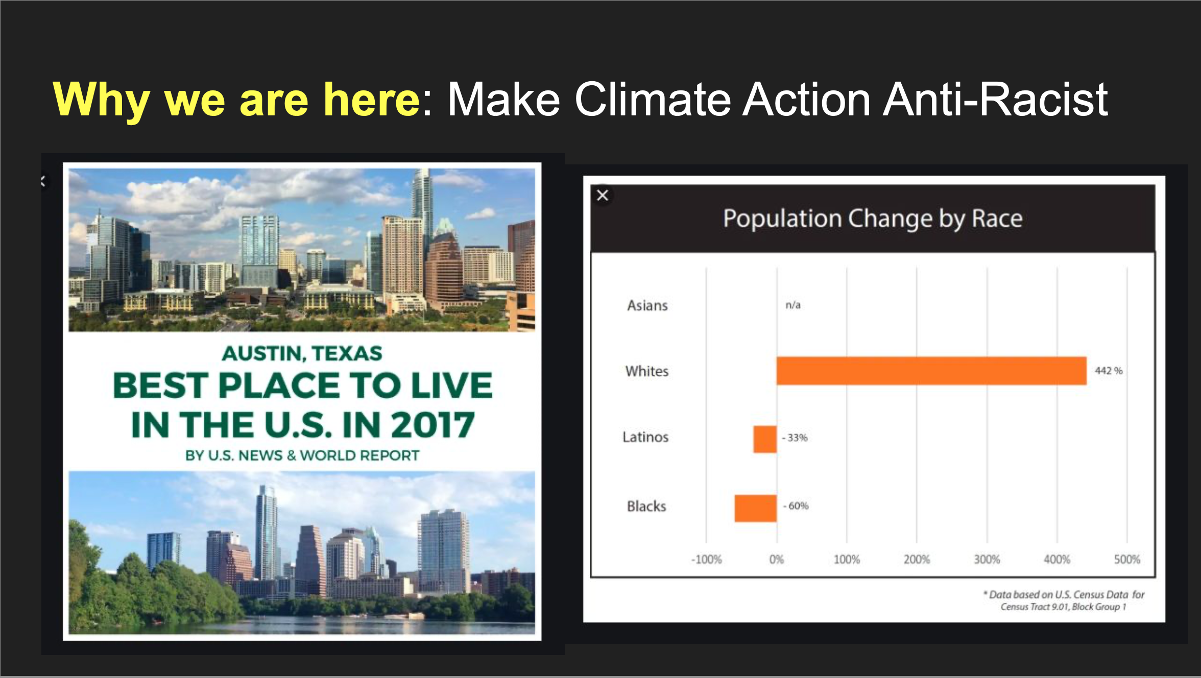
Using a combination of semiotic, ecological, and spatial frameworks, I explore how the city of Austin, Texas can be said to function as a schismotopia: a heterotopia that is simultaneously thriving and toxic in a way that denotes a complementary process of schismogenesis. In one obvious sense, Austin is heterotopian in that it has a long established, popular reputation as a “weird”, young, and progressive oasis in a sea of Texas conservatism. But behind this veil of distinction there lies another, more insidious contradiction. Austin regularly tops the charts on the best US cities in which to live, work, and to visit, coming in at #1 on the US News and World Report’s list of Best Places to Live in the USA for the past three years. However, Austin is also one of the most segregated and socially stratified cities in the US. And as a result, Austin is the only city of its size in the US whose black and brown population has been in a steady and appreciable decline for decades.
Building off of last year’s concept of Static, this photo essay continues to think semiotically about social and cultural forms of toxicity to explore how place can become schismogenetic. These series of images enable me to put forth that place, or the lived dimension of space, does not simply emerge in relation to either material space or to the hegemonic representations of that space, nor in equal relation to both; it is not simply triadic, but rather a third. That is, place is a subjective phenomenon that emerges, phenomenologically, through collective relations to the relationship between the materiality of a space and its hegemonic representation. To put this in Gregory Bateson’s terminology, place emerges at the trito-order in the way that people “learn to learn to receive signals,” or “in the changes whereby an individual comes to expect his [or her, or their] world to be structured in one way rather than an-other” (1987, 184). In their toxic form, certain changes in expectation between subjects or groups of subjects become schismogenetic in nature, meaning that they take on the quality of progressive differentiation. This photo essay explores how environmentalism, as a mode of placemaking, has exacerbated a schismogenetic relation between the Austin’s white and non-white population.
This image was produced by Tane Ward of Equilibrio Norte to provoke thought and conversation about the racism that is embedded in Austin's contemporary mode of placemaking.
Staying true to its “weird” reputation, Austin, Texas is a place full of contradiction and complications. On the one hand, the Austin community is praised as one of the most environmentally conscious cities, not only in Texas, but in the United States (World Resources Institute 2004). It’s numerous city-programs—including the Water/Wastewater Department’s Dillo Dirt, Keep Austin Beautiful, Water Conservation, Austin Recycles, Energy Conservation, Public Works, Green Builders, and the Propane Program—have won state and national recognition, contributing to Austin’s international recognition as an environmental leader (Gunn 2004). It has also remained relatively strong, economically, throughout the post-2008 depression, ranking at the top of the list of fastest growing cities in the country in 2011 (Busch 2017). On the other hand, Austin is one of the most unequal, racially-segregated cities in the US. Austin’s black communities have been repeatedly displaced over the course of the city’s development (Tretter 2016), leading to a continuous loss of population share every decade since the 1920's (Busch 2017). The city also stands out in the location of poverty. Efforts to keep the downtown “clean” and “green” have inspired strong networks of community policing of poverty and homelessness, forcing much of the homeless population into the suburbs. In East Austin, where numerous neighborhoods are currently undergoing gentrification, the poverty level of black residents is regularly 2,000 times greater than other local whites (Busch 2017).
This image was produced by Tane Ward of Equilibrio Norte to provoke thought and conversation about the racism that is embedded in Austin's contemporary mode of placemaking.
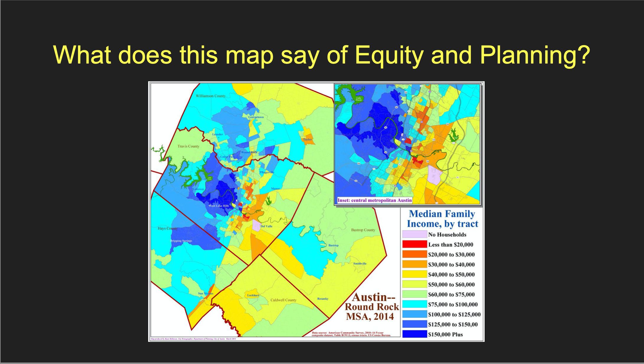
The segmented nature of Austin’s social space corresponds, to a large degree, with the history of its racial geography. Environmental risks are disproportionately distributed to East Austin, the area of town which, in the 1928 Master Plan, became designated as the segregated “negro district.” Since this designation, East Austin has been consistently subjected to environmental hazards.
Originally, the East Austin community was upset that the city used tax incentives to attract businesses that would bring little to no benefit to the East Austin community in which they were located (Tretter 2016). However, this focus took a notable turn after the discovery of chemical leaks and the illegal disposal of industrial waste from Austin’s Motorola Plant in 1982 and 1984. These events made local community leaders aware of the potential risks presented by having these facilities so close to home. Small sections of Central East Austin have also recently been targeted for clean-up and redevelopment, raising the property values in the area and, once again, forcing members of the black and brown community from their homes and residences. Many of Austin's liberal, progressives still consider this gentrification to be in accordance to the natural or logical development of a city. In their view, East Austin’s Desirable Development Zones are both dilapidated and cheap, and therefore the locations most suitable and in need of redevelopment. The incisive response of many local environmental justice groups is to point out that environmental racism was the cause of the dilapidation and poverty in the first place.
Asymmetrical power relations determine which environmental problems become visible as problems and therein capable of being addressed. As Tretter points out, though the ideology of smart growth rests three equal legs (economy, environment, and society), in Austin these legs have split into two factions: an economic-environmental interpretation of urban sustainability, and an environmental-social interpretation of environmental justice (2016).
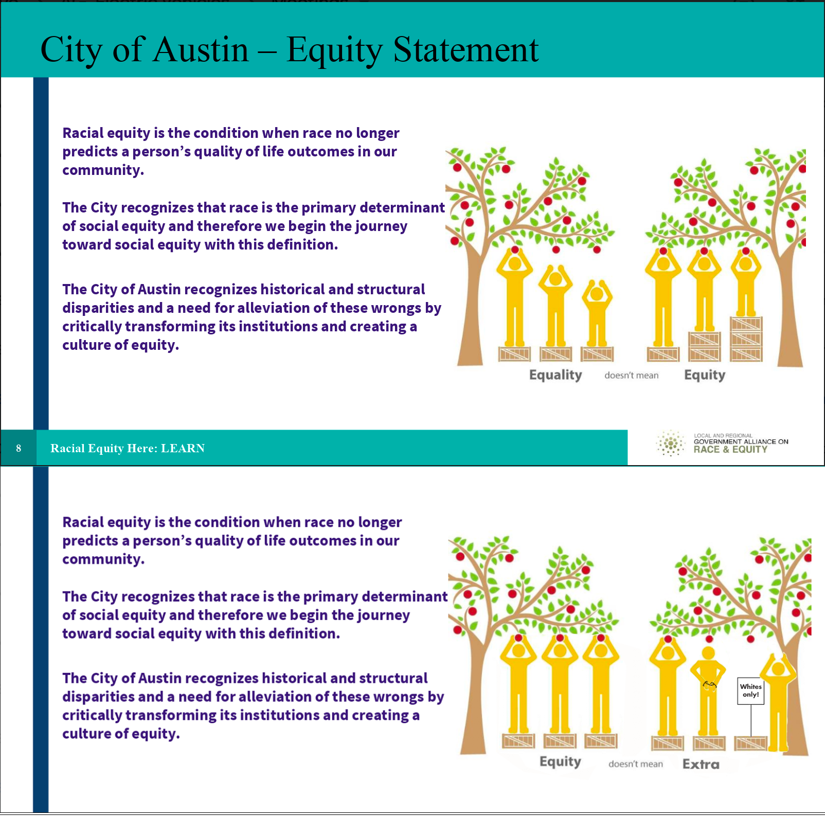
The top image in this combination is the “go to” slide for the City of Austin when they introduce their conception of equity. I've been bringing this image up during my interviews to see how it is read by more critical audiences. One of my interlocutors, Kenneth Thompson, associated this image with the national, hegemonic discourse of the city that excludes the vernacular discourses taking place in the homes of black families. “Right, like I need help, right, and so who does that really make feel better about that, right? … when they put that thing together, they probably thought, it looks good and it probably gave them the responses they thought they was gonna get. But if they did go out and add more people and add some deliberative thought to those things, right, then perhaps someone’d say, ‘Hey man, wait a minute, you’re makin me feel like I’m in need all the time.’”
In Kenneth's words, Austin is a very “liberal” place, but not a “progressive” place. The distinction he is making here is that a “liberal” place can utilize control over the public discourse to rationalize and get away with whatever agenda they have. A “progressive” place, by contrast, considers the consequences of development and policy actions for all involved parties, including the meanings and the values communicated through those actions.
Another interlocutor, Dr. Tane Ward, made similar distinction between saying things with language as apposed to images. In an interview he commented that images are "more profound than the written word. And this is why I think that people are allowed to say whatever they want, but they are not allowed to show whatever they want." This was Tane's response to the image: "which is exactly what I’m saying. You can say it... These words are good [referring to the text in the image]. This is precisely what we’re talking about… [but] people see this and they intrinsically are like, 'hmmm, I get what’s going on. They wanna give extra shit to black people.'”
The contrast between text and image in this slide bears a symmetry to the dissonance between the City’s actions and the national discourse on Austin. Austin's progressive reputation simply does not align with the lived experiences of many of Austin’s black and brown residents. This is one way of saying that, although Austin’s white and non-white populations simultaneously inhabit the same “space,” they live in and experience the city as very different "places."
Austin’s white population relates to the relationship between the ontological and discursive space of Austin in a way that enables them to assimilate their experiences into the hegemonic discourse about the city. That is, their experience does not incite Third Order Learning, or a change in their expectations for the way their city is or should be structured (Bateson 1987). Even the self-referential critique of Austin’s history, which is included in the text embedded in the image, feeds into this hegemonic perception of Austin as a socially just and progressive place. In Tane's words, "you know, 'yea, if I talk about anti-racism, I don’t have to f***ing do anything.' When in fact... they’re really promoting the continuation and even the augmentation of racism in terms of how resources are distributed."
Being born and raised in a poor neighborhood in East Austin, Kenneth was in one of the first groups of Austin’s black residents to be relocated to the “projects” in North Austin. He understands this move as effectively depriveing him and other low-income children of access to numerous resources, including local black teachers and role models. “See there was no longer no teachers there, there was no longer no doctors there, there was no longer no one that you could go and talk to that can give you a different perspective on life. … That’s part of the economic injustice, and part of the environmental injustice that you have to deal with also. And so, to some degree, what that also caused was early death. I mean, I’m 58 years old and I bet I can name you 30 people that I grew up with, that died before 30 years old. That’s not something that everybody can do, and that’s not something that everybody should be able to do. But when you think about the disparities, that’s what disparities lead to.”
Listening to stories like Kenneth’s helps to illustrate how this sort of superficially progressive image actually participates in the erasure and exclusion of black experiences. This image does so in the following ways: 1) the visualization seems to suggest that black people need “more” assistance to create an even playing field, rather than simply taking away or offsetting the present and historical structural barriers to self-determination; 2) the metaphor of height (a “natural” difference in ability) is unfit to represent these structural disparities in the quality of life between Austin’s black and white population; and 3) it is simply inappropriate to represent disparities that result from life-course changing, structural violence with primary colored boxes, apples, and stick figures.
The second image, by contrast, suggests that the City has and continues to actively participate in preventing racial equity. And it uses visual metaphors that simply hit harder than terms like "structural violence" to get at some of the difference between Austin’s progressive discourse and it’s liberal reality. The bottom image also gets rid of “height” as a metaphor for inequality and replaces it with symbols of physical (arm restraints) and legal (“Whites Only”) barriers imposed by the City.
What becomes apparent when you talk with Austin’s local black and brown populations is that they do have a dissonant relation to the relationship between Austin’s discursive and ontological space, and this has caused a change in their expectations (i.e. Third Order learning). As with all Third-Order learning, this change in expectation has the potential to be beneficial or deleterious, tonic or toxic.
Attempting to make Austin residents feel good and maintain the city’s progressive reputation may seem quite reasonable, but the dissonance between that representation and the situation of the city's black population has detrimental effects on the psycho-social dynamics of local black families. It presents young black folk with a double bind. They are being excluded from a conversation about inclusivity. I'll quote Kenneth again, “Two things happen, we start to feel like, first of all, that our voice doesn’t exist, right? And then you start trying to figure out, to some degree, why should you get involved? Why should you get involved when it appears that those who should be the architects of fairness, right, are still imbalanced with their media and with their messages?”
Kenneth went on to argue that it takes a special skill to survive in Austin as a black person, one that reflects a certain positive form of Third Order learning. You have to become good at taking in the bullshit, digesting it, and making it into something you can use to improve the situation for yourself and your family. Which is obviously a very difficult skill to cultivate.
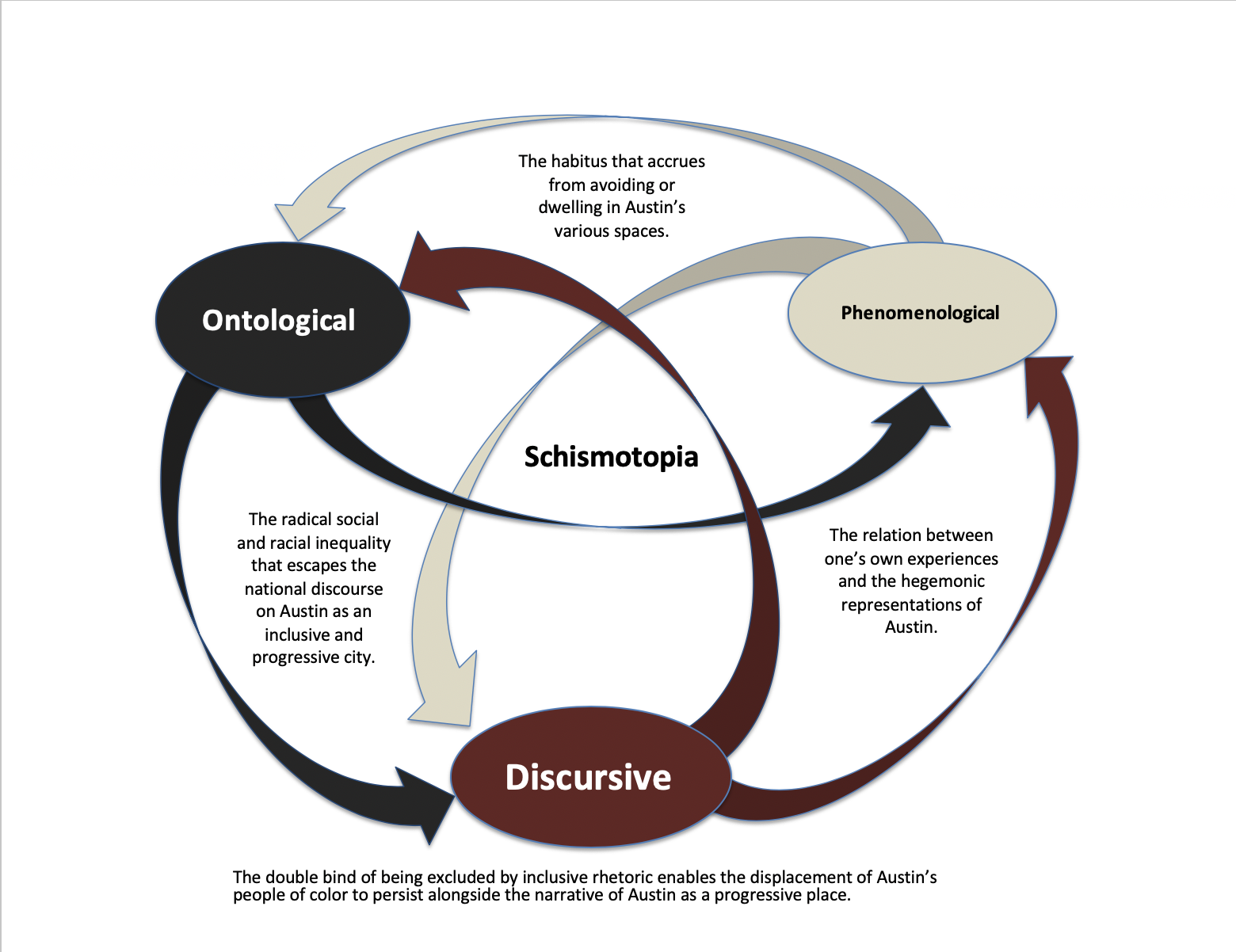
This diagram represents an attempt to think semiotically about "place" in Austin in terms of thirds (Kockelman 2010), of a relation to a relation (Serres 1982), and as a process of trito-order learning (Bateson 1987). Aucoin (2017) emphasizes the analytic distinction between “space” and “place” where the former is understood as a medium that can be materially, structurally, or symbolically altered to take on certain meanings for different groups. The latter, by contradistinction, is defined by how a space is lived or, to be more precise, how it “comes into being through human experience, dreaming, perception, imaginings, and sensation, and within which a sense of being in the world can develop” (Aucoin 2017, 396). This distinction creates a useful binary to think with but, as toxics often elude binary thinking (Fortun 2011), I place this dialectic relation in relation to another.
Lefebvre’s now classic triadic model of social space made use of its perceived, conceived, and lived dimensions. Using this model, space, in Aucoin’s sense, can be further broken down into a dialectic between Lefebvre’s first two dimensions: the perceived and the conceived. These dimensions were derived from the structural linguistic notions of signified and signifier. But, as a Marxist humanist committed to developing theory of political practice, Lefebvre bristled at this linguistic approach’s denial of the revolutionary potential of art and other non-linguistic forms of meaning and signification. He therefore introduced “lived space” as a third term that set the dialectic off balance and allowed for temporality and difference to be incorporated into spatial structure.
While this “third term” does indeed create room for politics, given our focus on toxicity, I am interested in how these relations can become progressive in ways that are deleterious. I will put forth that place, or the lived dimension of space, does not simply emerge in relation to either the perceived or the conceived, or in equal relation to both; it is not simply triadic, but rather a third. That is, place is a subjective phenomenon that emerges, phenomenologically, through collective relations to the relationship between the ontological and the discursive dimensions of social space.
For a closer look at a breakdown of the concepts that build up to Schismotopia, see this photo essay.
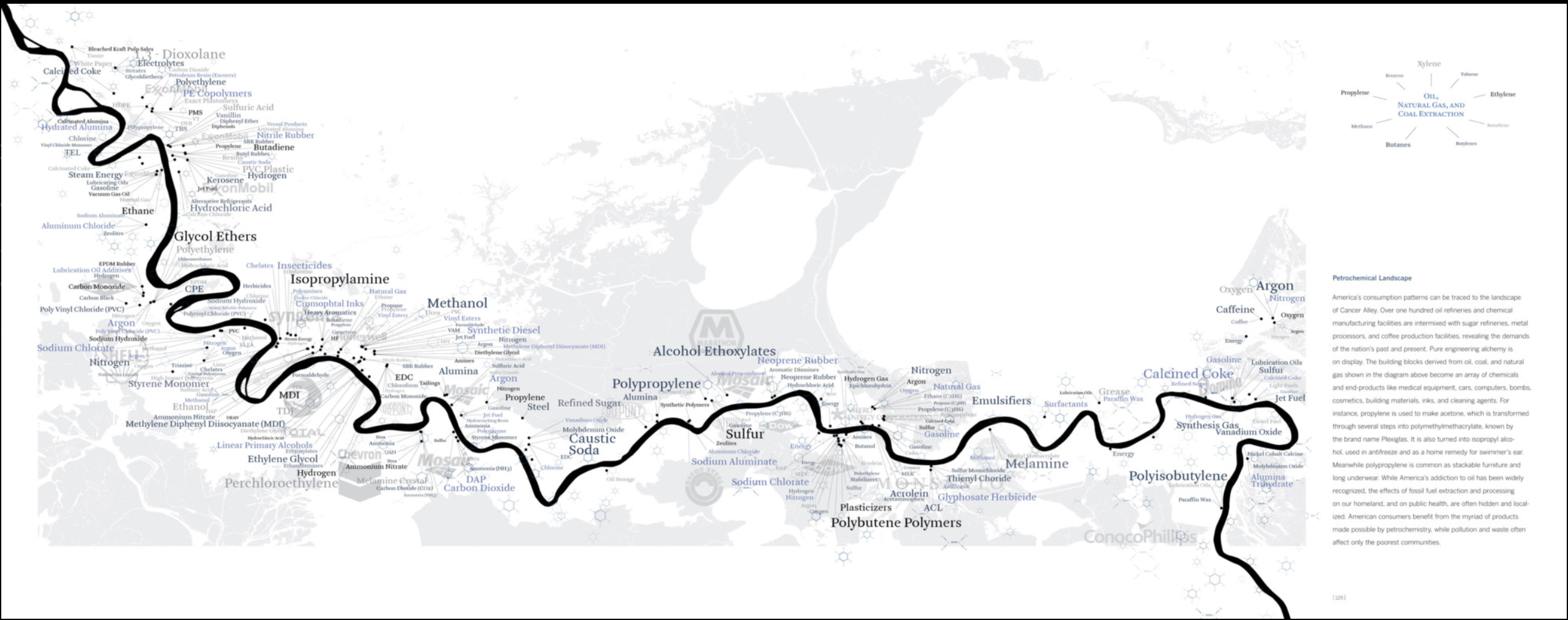
I am interested in visualizing the workings of the multinational Taiwanese petrochemical manufacturer Formosa Plastics. The company is implicated in causing severe environmental problems: in Texas, activists recently achieved a historic settlement of $50 million to mitigate the release of small plastic pellets (“nurdles”) in the ocean; in Louisiana’s “cancer alley”, StopFormosa.org and the Louisiana Bucket Brigade fight the construction of a new $9.4bn plastic plant; in Vietnam, a chemical spill caused the country’s worst environmental disaster, threatening the livelihood of 40,000 fishermen; and in Kaohsiung, activists are pushing back against the expansion of a 20 year old naphtha cracker complex.
The literal places that Formosa inhabits – or plans to inhabit – are toxic for obvious reasons, as they have a significant toxic chemical load in water, air and soil. In Kaohsiung, the industrial infrastructure is aging and not well documented. Then, there is also China’s digital misinformation campaign leading up to the recently held Taiwanese elections, including the results that could increase pressure from Beijing. In Louisiana, activists highlight that the new facility is known to be located on two slave burial grounds. The Texas activists report that, despite their success, new plastic waste is continuously released into the ocean.
Thinking about the visual side has been more tricky so far. Building on Kim’s research on Bhopal brings to mind the ongoing attempt to map and visualize the operations of a multinational chemical industry. A group of Taiwanese journalists won the 2019 data visualization prize for an animated film about the naphtha cracker, but it’s mostly a national story. What does it mean to think of Formosa as globalplace?
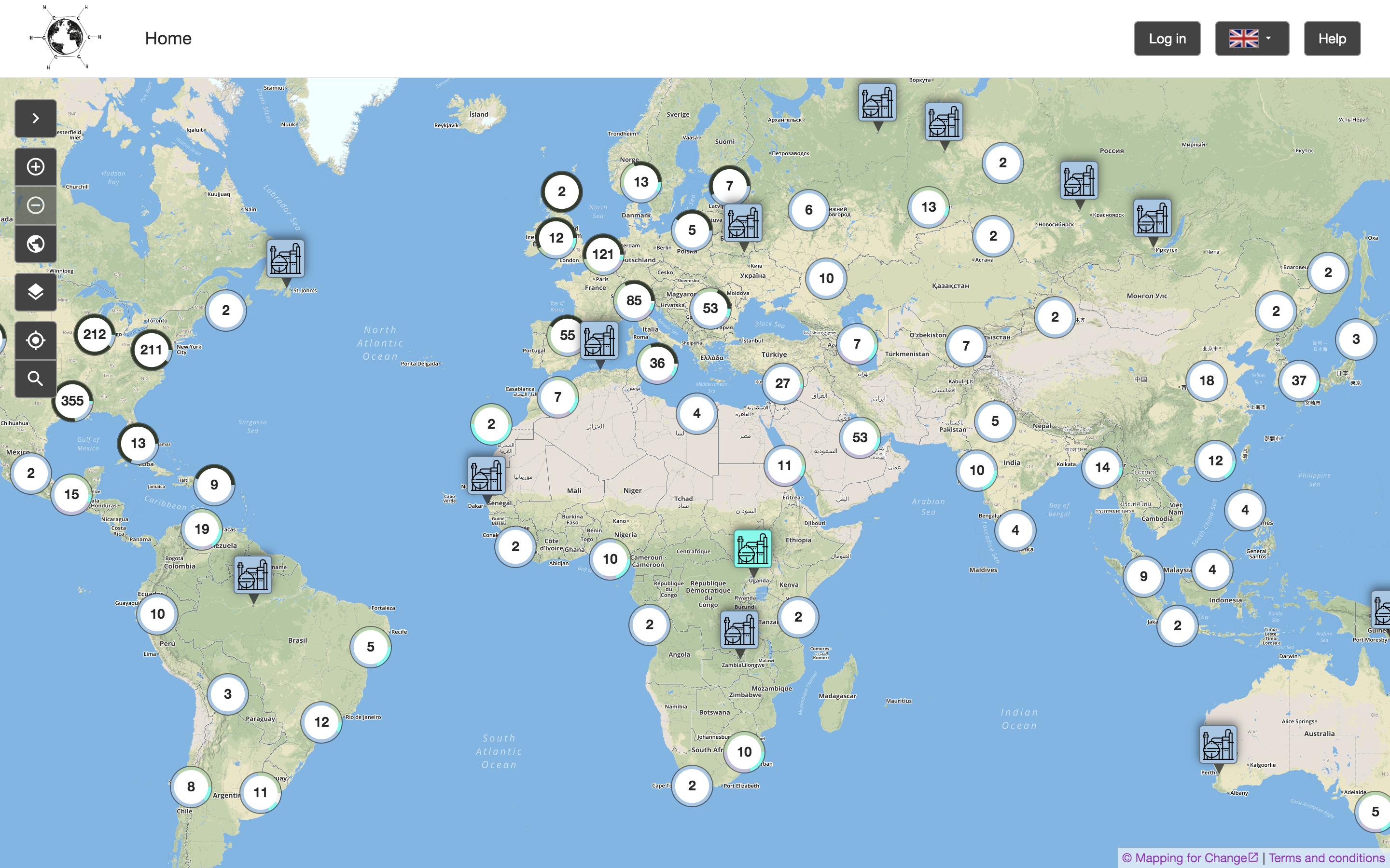
This is a screenshot I made of the "Global Petrochemical Map", an interactive visualization website. The map was created by researchers in the European Research Council-funded Toxic Expertise project. The project team's goal is to "map cases around the globe of major petrochemical sites, local communities, community and labour mobilisations, and details of emissions, environmental and safety records, photos, and media reports."
I came across the map in my search for a "global" view of Formosa Plastics, a visualization that would include all the different Formosa-run facilities. This screenshot, however, shows petrochemical plants across the globe. Certain facilities are highlighted, because they feature extra-information, including both quantitative toxic release information and qualitative data (narrations, images, ... ) submitted by users. While many Formosa facilities can be found on the map, they often feature only either of these types of data – or sometimes nothing at all. It also remains unclear what kind of data – including visuals – might be effective for this kind of website.
The visualization might serve as a reminder for the well-known STS partial view that a "god's eye" view of the world produces. At the same time, it seems to be an attractive point of entry to start mapping out all of Formosa's activities at once.
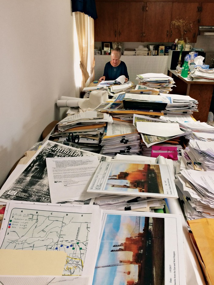
This is a photograph of "community chemist" Wilma Subra, taken by Rick Mullin. Mullins visited Subra in her office in Southern Louisiana and conducted an interview with her. The image appeared as part of a published article on the website Chemical & Engineering News (Janurary 2020).
In the interview, Subra recounts her training as a microbiologist and chemist, who eventually became a leading consultant for the EPA, but also NGOs and other community organizations. Though she has worked on cases of industrial pollution across the U.S., she is particularly well-known in Louisiana's "cancer alley". Currently, she is involved with the pushback against the opening of new Formosa petrochemical plants.
Both the visual and article focuses on the printed "emission data and regulatory filings" that line Subra's kitchen table, which also serves as her office. The photograph creates a feeling of awe for the masses of paper, with Subra positioned at the vanishing point. The author highlights how Subra's company, starting with a small set of employees, eventually became a "one-woman shop."
I chose the image for my essay because of this effective contrast, certainly heroic contrast – the masses of paper that a single engaged scientist is challenged to wade through. It also visualizes my own research concern with "archiving for the Anthropocene" – what will ways of storing, accessing and analyzing toxic environmental data need and look like in the future?
Further, in terms of literal place, where will the data be stored? Interestingly, the article does not raise the question of where all of these files could be kept. Subra recounts instances where she and her apartment have been violently attacked by potential goons of the petrochemical industry. Keeping records in your own home raises concerns of safety and vulnerability, of data and its scientists.
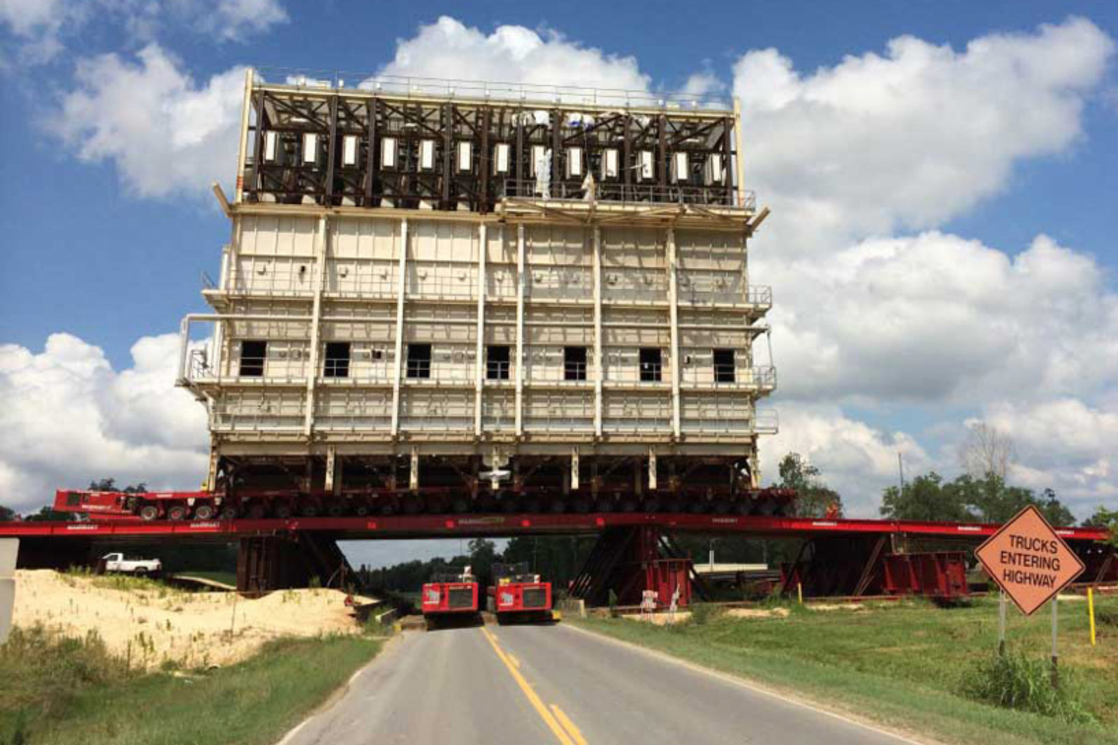
This photograph is courtesy of Mammoet, a Dutch company that brands itself as the "global market leader in engineered heavy lifting and transport." The visual was featured in a 2019 report by ProPublica about the cost-cutting strategies of petrochemical companies. In Louisiana, these companies benefit from tax breaks, while promising both permanent and temporary jobs. As the article shows, the companies forego a lot of the promises by assembling chemical plants outside of the US and then shipping them back.
The visual is a documentation of this practice, the caption reads: "A steel bridge was constructed over the Mississippi River levee so that pieces of a methanol plant could be unloaded from a ship that carried the facility from Chile."
Following anthropologist Stefan Helmreich's work on the FLoating Instrument Platform (FLIP) – a research vessel that can move from horizontal to vertical – the visual of the massive steel construction on the levee creates a sense of wonder. Something similar be said for the photograph taken of the ship delivering parts of the chemical plant.
Verticality is also what matters in Formosas work: "One important way in which we differentiate ourselves in our marketplaces is through the extensive vertical integration of our supply chain. We produce oil and gas and transport these raw materials through our subsidiary Lavaca Pipe Line Company, then our Formosa Hydrocarbons Company processes natural gas into its components for use by our production plants. In addition, many products are delivered to our customers through our own fleet of large, modern railcars."
Though this description is of the chemical refining process, the visual might serve to push back against the smooth and effortless depiction of assembling a chemical plant in the first place.
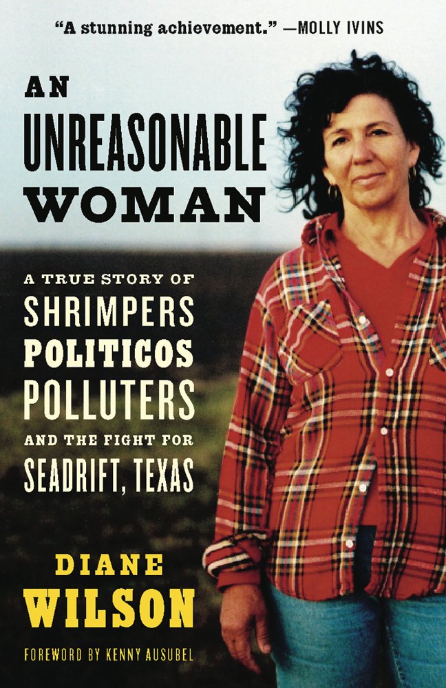
This is the cover image of the autobiography "An Unreasonable Woman", written by Diane Wilson and published in 2005. Wilson grew up around Seadrift, TX and made a living as a shrimp fisher. More than 30 years ago, she became invested in fighting petrochemical facilities in the area, including Formosa Plastics, which opened their 2,500 acre complex in 1983.
Wilson's career as an activist is remarkable in many ways. In a 2019 interview, she recounts how learning about the high air pollution in the area – first published in light of the Bhopal disaster, right-to-know legislation and toxic release inventories (TRI) – got her interested in knowing more. Early on, companies she called up would refuse to hand out numbers to her and overall did not take her seriously. Later, she would engage in various civil disobedience actions, including a hunger strike and sinking her own shrimp boat on a Formosa discharge pipe. Most recently, a group of activists that she is part of won a $50 million lawsuit against Formosa; in the interview, Wilson says that she feels like it's "the first time that justice has been achieved."
The photograph is striking for her determined outlook and posture, paired with her every day (work?) clothes. It indicates a dynamic of activism in a toxic environment (in the double sense) -- e.g. not being taken seriously, being talked down to. It also points to the different stakeholders involved in the fight againstt Formosa, such as shrimpers depending on their livelihood.
The photograph of Wilson and the re-appropriated slur of being "unreasonable" have become somewhat iconic in the protest against Formosa. In their interview, LA-based environmental activist Brooking Gatewood mentions that she was so inspired by Wilson's work that founded an environmentalist group named "Unreasonable Women."
In late March, I will be part of a small group visiting Wilson in Texas. Including her image in this photo essay, I hope to think further about what makes the image ethnographic (in addition to and beyond autobiography) and how it could be used in contrast or comparison with other visuals across the submitted projects.
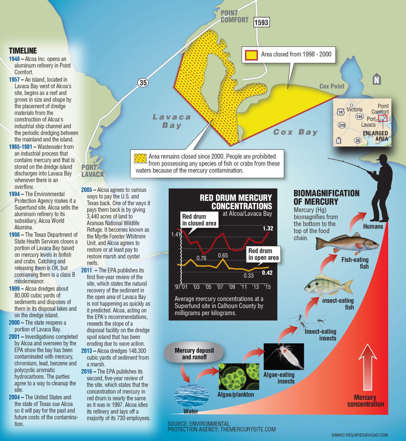
In Point Comfort, TX, the aluminum producer Alcoa has polluted the waters of Lavaca Bay with mercury, leading to an EPA superfund site. This visual provides a timeline of the pollution history, an overview of the affected area and the process of biomagnification throughout the food chain. In a 2019 interview, Diane Wilson highlights that the plastic pellets discharged by Formosa have shown to absorb the mercury, producing compounded toxicity.
I included the image here for two reasons: 1) looking at the map after listening to the interview reveals the exclusions that are inevitably produced by the map's focus on mercury 2) it serves as a token representation for maps that aim to be comprehensive and bring different data sources into view (historical development of the plant, geographic markers, scientific graphs).


This image was produced by Tane Ward of Equilibrio Norte to provoke thought and conversation about the racism that is embedded in Austin's contemporary mode of placemaking.
The segmented nature of Austin’s social space corresponds, to a large degree, with the history of its racial geography. Environmental risks are disproportionately distributed to East Austin, the area of town which, in the 1928 Master Plan, became designated as the segregated “negro district.” Since this designation, East Austin has been consistently subjected to environmental hazards.
Originally, the East Austin community was upset that the city used tax incentives to attract businesses that would bring little to no benefit to the East Austin community in which they were located (Tretter 2016). However, this focus took a notable turn after the discovery of chemical leaks and the illegal disposal of industrial waste from Austin’s Motorola Plant in 1982 and 1984. These events made local community leaders aware of the potential risks presented by having these facilities so close to home. Small sections of Central East Austin have also recently been targeted for clean-up and redevelopment, raising the property values in the area and, once again, forcing members of the black and brown community from their homes and residences. Many of Austin's liberal, progressives still consider this gentrification to be in accordance to the natural or logical development of a city. In their view, East Austin’s Desirable Development Zones are both dilapidated and cheap, and therefore the locations most suitable and in need of redevelopment. The incisive response of many local environmental justice groups is to point out that environmental racism was the cause of the dilapidation and poverty in the first place.
Asymmetrical power relations determine which environmental problems become visible as problems and therein capable of being addressed. As Tretter points out, though the ideology of smart growth rests three equal legs (economy, environment, and society), in Austin these legs have split into two factions: an economic-environmental interpretation of urban sustainability, and an environmental-social interpretation of environmental justice (2016).